Saturday, July 24, 2010
Bridges on the Singapore River (2010)
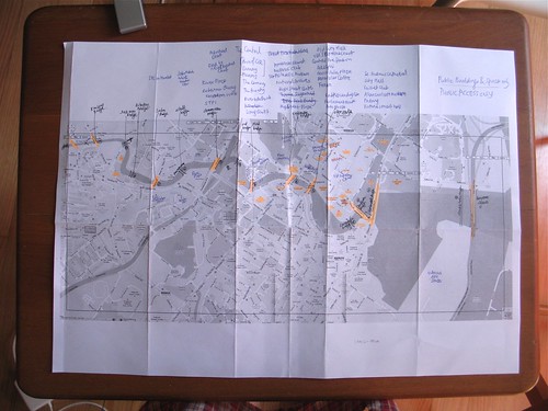
- Kim Seng Bridge 金声桥 (Vehicular Bridge: Kim Seng Rd) [This marks the source of the SIngapore River, named after Peranakan philanthropist Tam Kim Seng, whose donations help pay for the construction cost of this bridge.]
- Jiak Kim Bridge 若锦桥 (Pedestrian Bridge: Behind Zouk) [Completed 1999, CPG. Built to develop Roberson promenade by improving connectivity between both sides of river around Roberson Quay Area]
- Robertson Bridge 罗拔申桥 (Pedestrian Bridge: ) [Completed 1999, CPG. Built to develop Roberson promenade by improving connectivity between both sides of river around Roberson Quay Area]
- Pulau Saigon Bridge 浮罗西贡桥 (Vehicular Bridge: Saiboo St) [Originally built in 1890, demolished in 1986, rebuilt 1997]
- Alkaff Bridge 阿尔卡夫行人桥 (Pedestrian Bridge: By Roberson Promenade, behind Mohammad Sultan Rd) [Completed 1997, CPG. Built to develop Roberson promenade by improving connectivity between both sides of river around Roberson Quay Area, decorated as "Art Bridge" by Pacita Abad with STPI]
- Clemenceau Bridge 克里门梭桥 (Large Vehicular Bridge: near UE Square and Clemenceau CTE exit) [Completed 1920, named after French Prime minister]
- Ord Bridge 渥桥 (Pedestrian Bridge: Liang Court) [First built 1886] Steel Truss bridge built to replace footbridge named ABC Bridge which was also known as Ordnance Bridge. Named after Sir Harry St. George Ord, first british Govt of Straits Settlement.
- Read Bridge 李德桥 (Pedestrian Bridge: Clarke Quay and Riverside Point) [Previously Merchant Bridge which had to be rebuilt higher to allow ships to pass, Read Bridge was rebuilt in the same spot in 1889]
- Coleman Bridge 哥里门桥 or "Yi ma lo khiu" (cantonese for bridge at second road) (Vehicular Bridge: New Bridge Road, MICA to The Central) [2nd bridge built over Singapore River in 1840, made of bricks. Replaced in 1865 with wooden bridge, replaced with iron in 1886, but unable to cope with increasing traffic flow, replaced with 1986 concrete bridge which retains some decorative elements from iron bridge. Previously known as New Bridge thus the name of New Bridge Road.]
- Elgin Bridge 爱琴桥 or "Thih Tiau Kio" (hokkien for iron suspension bridge) (Vehicular Bridge: North Bridge to South Bridge Rd) [First and unnamed footbridge on Singapore river which was present when Raffles first landed. Replaced by wooden drawbridge in 1822, a footbridge in 1843 and rebuild int 1929 and named after Lord Elgin, Governor General of India. As it was first bridge ever, the roads are named North Bridge and South Bridge accordingly]
- Cavenagh Bridge 加文纳桥 (Pedestrian Bridge: ACM to Maybank Tower and One Fullerton) [First built in 1869, originally was to be drawbridge but on completion was only suitable as fixed structure. overloaded in 1880s and resulted in need to build Anderson Bridge. Lighting was added in 1990s]
- Anderson Bridge 安德逊桥 (Vehicular Bridge: Connaugh Dr) [First built in 1910 to replace Cavenagh Bridge and to handle heavier traffic, named after Sir John Anderson, Governor of Straits Settlement]
- Esplanade Bridge 滨海桥 (Large Vehicular Bridge: Nicoll Highway leading to Esplanade Dr) [Completed March 1997 / Built to provide faster access from Marina Centre/Downtown Core to Shenton Way and CBD]
- The Helix Bridge 螺旋桥 (Pedestrian Bridge: Marina Bay) [Completed 24 April 2010]
- Bayfront Bridge 海湾桥 (Vehicular Bridge: Bayfront Avenue) [Completed 24 April 2010]
Compiled with the help of Mighty Minds Street Directory 2009/2010, Google Maps, Streetdirectory.com, rednano, Wikipedia, and Stephen Dobb's "The Singapore River : A Social History 1819-2002"; the chinese names were from 韩山元's "新加坡河: 讲不完的故事" and a very interesting chinese blog by the name of Kagawara Miss Flora.
Other Singapore Map Trivia:
- The 2009/2010 edition of the Mighty Minds Street Directory erroneously named the "Pulau Saigon Bridge" as "Saiboo Bridge". While trying to figure out why my map reflected a mysterious Saiboo Bridge I discovered this helpful article about the Pulau Saigon Bridge
- Gothere.sg and Google Maps do not depict or show the existence of ANY pedestrian bridges on their maps. They do show vehicular bridges, but do not name the bridges, and only label the river crossings with the road names.
- Streetdirectory.com and Rednano.sg do show the names of all bridges, both pedestrian and vehicular.

No Responses